AquaINFRA
Horizon Europe project AquaINFRA – Infrastructure for Marine and Inland Water Research
Background
The oceans, seas, coastal, and inland water are part of the water cycle, which is currently under unprecedented pressure. Restoring and protecting these waters is an urgent task addressed by the EU Mission “Restore our Oceans and Waters” by 2030. The mission aims to reduce human pressure, restore ecosystems, and sustainably utilize services. This requires up-to-date, high-quality data available under FAIR principles, covering the entire water continuum and addressing the DPSIR framework. To restore healthy waters, new methods of data search, acquisition, analysis, and modeling are needed.
Objectives
The AquaINFRA project aims to develop a virtual environment equipped with FAIR multi-disciplinary data and services to support marine and freshwater scientists and stakeholders restoring healthy oceans, seas, coastal, and inland waters.
The AquaINFRA virtual environment will enable stakeholders to store, share, access, analyze, and process research data and other digital objects from their respective disciplines, across research infrastructures, disciplines, and national borders. This will be achieved by leveraging the European Open Science Cloud (EOSC) and other existing operational dataspaces. In addition to supporting the ongoing development of the EOSC as a comprehensive research infrastructure, AquaINFRA specifically focuses on enabling collaboration between researchers in the marine and freshwater communities.
A specific goal of AquaINFRA is to develop an EOSC-based research infrastructure that combines the marine and freshwater domains. This will include the development of a cross-domain and cross-country search and discovery mechanism, as well as the building of services for spatio-temporal analysis and modelling through Virtual Research Environments.
Co-designing and testing services in the targeted research communities will be facilitated through a set of strategic use cases, including a pan-European use case, as well as more focused use cases in the Baltic Sea, the North Sea and the Mediterranean.
HELCOM’s involvement
The project is coordinated by Aalborg Universitet (AAU) and has 21 international partners. HELCOM is involved in two of the seven work packages:
WP3: Data discovery and access system
The objective of this work package is to co-design an EOSC-compliant pilot service that enables AquaINFRA users to seamlessly and easily find and access harmonized data from (1) the diverse set of pan-European and national metadata catalogs, and (2) existing data infrastructures that host marine and freshwater data, along with associated Earth system science, socioeconomic, and biodiversity data.
WP5: Use cases
This work package aims to demonstrate the practical application of project components and services through actual use cases across Europe (see below).
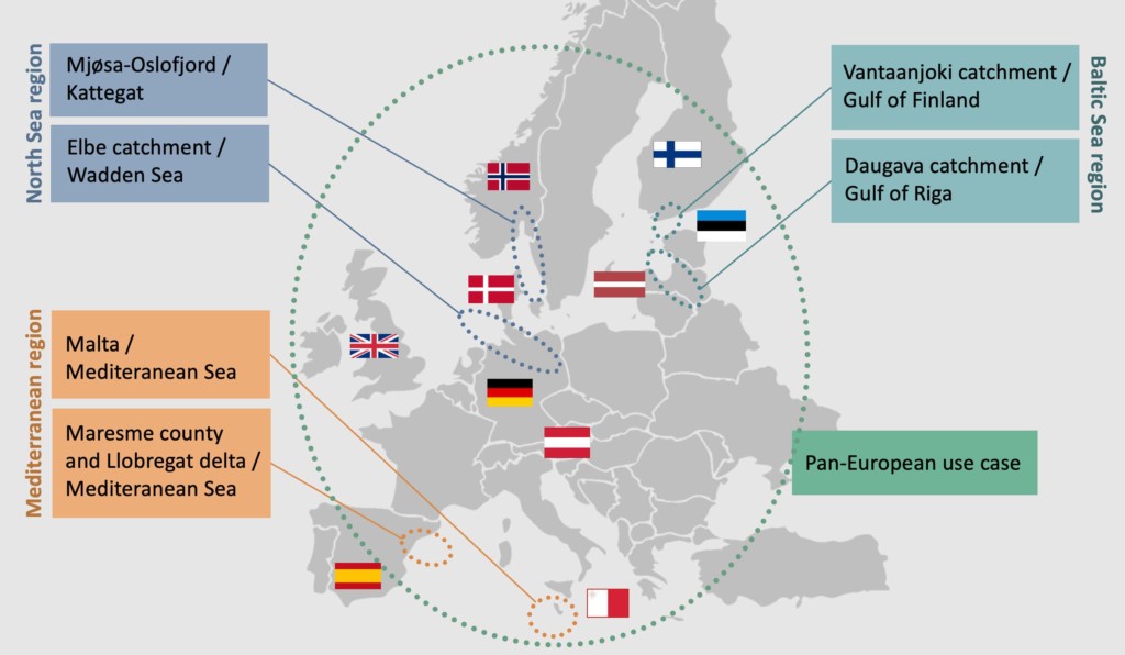
HELCOM acts as the task leader for the Baltic Sea region use case, which will involve identifying the presence, content, and formats of data produced under HELCOM and EU policies and instruments. This data is required for evaluating the cost, benefit, and effectiveness of management measures for two specific cases: river basins in southern Finland and the Daugava River-Gulf Riga in Latvia. Based on the identified data, data flow models applicable to the Baltic Sea region will be developed, integrated, and tested in the ongoing HELCOM assessment processes. These models will be verified by the HELCOM community of national representatives to ensure their applicability throughout the broader region.
Furthermore, recommendations will be formulated to guide the further implementation of the FAIR principles. These recommendations will focus on the types of open data and level of detail required to assess the effectiveness of ecosystem and water management measures, considering their social and economic impacts within the DAPSI(W)R(M) management cycle. The identified data will be combined with additional information such as earth observation data on catchment characteristics, water quality of rivers, high-resolution data on discharges, etc. These diverse datasets will be integrated into existing model frameworks to demonstrate the use of the identified data beyond its original data silo.
The key output will be a data flow model for evaluating of the effectiveness of measures, based on their social and economic effects.
Project duration
The project runs from January 2023 to December 2026 and is co-financed by the European Union.
Resources
Contact
Dmitry Frank-Kamenetsky
HELCOM Special Advisor
dmitry.frank-kamenetsky@helcom.fi
+358 40 630 9933
Luke Dodd
HELCOM Project Researcher
luke.dodd@helcom.fi
Joni Kaitaranta
HELCOM Senior Data Manager
joni.kaitaranta@helcom.fi
+358 46 850 9206
Lotta Ruokanen
HELCOM Professional Secretary
lotta.ruokanen@helcom.fi
+358 40 505 0392


