Baltic Marine Environment
Protection Commission


Baltic Marine Environment
Protection Commission

Revamped data page provides easier access to Baltic Sea information

HELCOM has updated its data page to offer a more accessible and user-friendly experience, ensuring that all its data products are now easier to find and navigate.

HELCOM collects and maintains a wealth of data on the Baltic Sea, organizing it into various thematic databases accessible through online data portals and services. The newly updated page provides a clearer overview of these resources, making it simpler for users to explore and utilize the information.

HELCOM’s data products can be categorised in four groups:

  • Data portals:  Currently, HELCOM hosts seven data portals, including the HELCOM Map and Data Service (MADS), which contains all geospatial data used in HELCOM assessments and reports.
  • Databases: HELCOM hosts, co-hosts or contributes to 12 databases, covering key topics such as shipping accidents and oil spills. These databases are regularly updated, following regionally agreed reporting formats and quality assurance procedures.
  • Data services: Beyond data access, HELCOM also offers data services that enable machine-to-machine communication, allowing GIS professionals, developers, and researchers to seamlessly integrate HELCOM datasets into their workflows.
  • Data services: A variety of software tools, developed specifically for HELCOM assessments, are also available through HELCOM’s GitHub repositories.

To explore the updated data page and access HELCOM’s data products, visit: https://helcom.fi/baltic-sea-trends/data

Contact:

Joni Kaitaranta
Senior Data Manager, HELCOM
joni.kaitaranta@helcom.fi

New HELCOM indicator reports provide the latest evaluations of Baltic marine environment

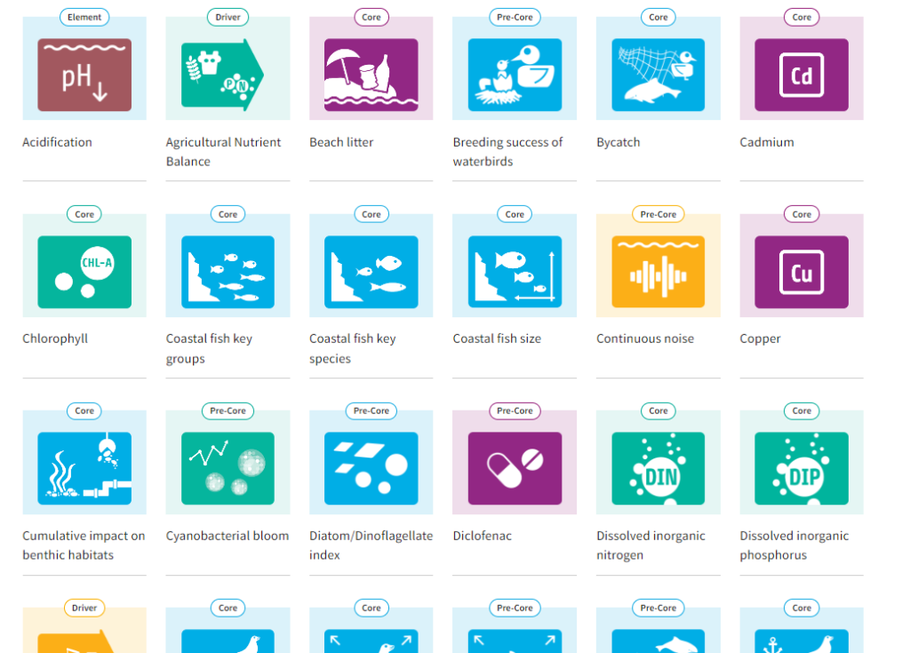
The latest indicator evaluations on the status of the Baltic Sea marine environment have been published on the new HELCOM indicator website. The total number of indicators now amounts to 59, covering several major components of the Baltic Sea ecosystem including pelagic and benthic habitats, fish, waterbirds and marine mammals, as well as a number of human-induced pressures.

New indicators include the abundance and distribution of the harbour porpoise, the amount of beach litter, shallow water oxygen, as well as concentrations of copper, among others. Previously, there was no agreement or methodology in place to assess the status of these topics.

Several indicators also apply preliminary threshold values (for example, for underwater noise) and where possible, the threshold values have been made compatible with EU-wide processes. For the first time, threshold values for the number of drowned mammals and waterbirds in fishing gear (bycatch indicator) have been applied.

The HELCOM indicators support measuring progress towards regionally agreed targets and objectives defined in the Baltic Sea Action Plan (BSAP). The indicators provide a mechanism to monitor the effectiveness of the measures that have been put in place by regularly synthesizing common regional data into an evaluation of progress towards these goals and the BSAP vision. The evaluations contribute directly to the third HELCOM holistic assessment (HOLAS 3).

On the new website, the indicators can be filtered by type (driver/element/pressure/state), category (core/pre-core/supplementary) as well as policy relevance (BSAP segment and MSFD criteria). The development of the new HELCOM indicator website was implemented by the HELCOM BLUES project, co-funded by the European Union.

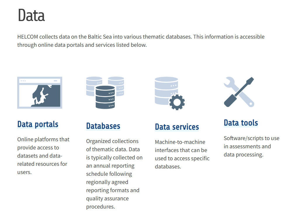
About HELCOM indicators

HELCOM indicators are developed to evaluate the status of biodiversity elements, evaluate other relevant environmental condition factors, evaluate human-induced pressures on the Baltic Sea, and support broader assessments and overviews in the region.

HELCOM indicators are measured in relation to regionally agreed threshold values, which are specific to each indicator. They may take the form of maximum, minimum or a range of values, and there can be variation in the threshold value(s) within an indicator (sub-regional) and between indicators.

The outcome of an indicator evaluation is expressed in terms of failing or achieving the threshold value and this is therefore indicative of if good environmental status is achieved or not for each specific indicator.

The indicators are selected based on ecological and policy relevance, measurability with monitoring data, and linkage to anthropogenic pressures. They are then developed by lead experts through regional cooperation, using the best available scientific knowledge. Each indicator is regularly reviewed and updated by technical and policy experts from across the region (HELCOM Expert and Working Groups). The work on introducing new indicators continues to cover all relevant topics and issues.

More information about the indicators can be found in the Indicator Manual.

HELCOM revamps its metadata catalogue, improving the search of over 1000 Baltic Sea maps

Screenshot of the revamped HELCOM Metadata Catalogue

HELCOM has recently launched its revamped HELCOM Metadata Catalogue, a tool that provides context and background to the datasets in the HELCOM Map and Data Service, which contains Baltic-specific geospatial data ranging from status assessments to shipping density maps, and totalling up to more than 1,000 individual maps.

“With the new catalogue, our users can easily browse or search metadata records, such as information on data collection, lineage, attribute descriptions, date published, format, INSIPRE theme and so on, to quickly acquire context on the dataset and establish if it is relevant for their needs,” said Matthew Richard, the HELCOM coordinator of the Baltic Data Flows project.

The updated resource now has an easy-to-use web interface to search geospatial data across multiple catalogues. The search provides full-text search as well as faceted search such as on keywords, resource types, organizations or scale. Users can easily refine the search and quickly get to the records of interest. 

“The HELCOM Metadata Catalogue is now INSPIRE compatible in terms of metadata standards on HELCOM datasets,” said Richard. “This is important to ensure compliance under the EU INSPIRE directive that aims to facilitate the harmonisation, sharing, and reuse of spatial datasets with multiple users and decision-makers across Europe.”

The Metadata Catalogue is built on the latest stable GeoNetwork version 3.12, which is designed to manage spatially referenced resources that provides powerful metadata editing and search functions. 

The HELCOM GeoNetwork implementation has been configured to be INSPIRE compatible in terms of metadata on datasets and contains a tool to validate metadata records against the INSPIRE validator. The INSPIRE validator and thesauri were used during development to ensure all metadata records are INSPIRE compliant. The metadata catalogue has also been configured for data harvesting to the ‘data.europa.eu’, and other relevant metadata harvesting initiatives.

The catalogue was updated as part of the Baltic Data Flows project, which seeks to enhance the sharing and harmonisation of data on the marine environment originating from existing sea monitoring programmes, and to move towards service-based data sharing. The project is being led by HELCOM and co-financed by the Connecting Europe Facility of the European Union.

Intercalibration between laboratories measuring nutrients and heavy metals is carried out, report published

To improve on the quality of monitoring data in the Baltic Sea, an intercalibration of analyzing methods of nutrients and heavy metals was recently carried out involving 22 laboratories across the region. The results were published in a report.

Financed by HELCOM, the intercalibration was carried out by the Danish Centre for Environment and Energy (DCE) of Aarhus University, on behalf of the HELCOM Pollution Load Compilation (PLC-8) project.

“For accurate Baltic-wide assessments of nutrient and metal concentrations, intercalibration between laboratories is crucial as it guarantees the compatibility of reported data, basically allowing us to compare apples with apples,” said Dmitry Frank-Kamenetsky, the coordinator of the HELCOM Pollution Load Compilation (PLC) projects. 

HELCOM now regularly organizes intercalibration campaigns at the beginning of each PLC project, to assure compatibility of reported data regarding nutrients and heavy metals. The latest campaign was already the third of its kind.

“The more we intercalibrate, the better data we get,” said Frank-Kamenetsky. “The good results of the recent intercalibration exercise confirm the trend of a continuous improvement of environmental monitoring data produced by the HELCOM countries.”

Three questions to… Lars Sonesten on the Second World Ocean Assessment (WOA II)

Lars Sonesten is the Head of Department of Aquatic Sciences and Assessment at the Swedish University of Agricultural Sciences (SLU). He is the Chair of the HELCOM Pressure Working Group as well as the Chair of the OSPAR INPUT Working Group. He was a member of the WOA II expert team.

What are the benefits of the WOA II for the global ocean?

Lars Sonesten: I think that the main benefit of WOA II is that it takes the alarming status of and our concerns about the seas and coastal areas to the highest political level worldwide. Hopefully, this may inspire national and regional authorities and organisations to increase their efforts to counteract the deterioration of our common seas.

What are the benefits of WOA II for the Baltic Sea region in particular?

First of all, it puts the environmental status of Baltic Sea into a global context, and makes it possible to compare with other sea areas. In addition, I think that our long experience as a regional sea convention in monitoring and joined assessing the status, as well as taking measures to combat the deterioration may serve as a good example for other sea areas.

What was your personal involvement in the WOA II process?

I was involved in writing the two chapters on inputs of nutrients and hazardous substances to the seas (chapters 10 and 11, respectively), with special responsibility on the atmospheric inputs of hazardous substances. As the chairman of HELCOM Pressure and OSPAR Input, I had an interest to share and incorporate as much relevant information as possible that is related to the Baltic Sea as well as the Northeast Atlantic.


About WOA II

The Second World Ocean Assessment (WOA II) assesses the state of the global ocean in the period of 2016 to 2020. Carried out by the UN’s Regular Process with the support of more than 300 experts, it covers environmental, economic and social aspects about the marine environment. While the first cycle (WOA I) focused on establishing a baseline, the WOA II follow-up effort also evaluates trends should support policy development and decision-making at the national, regional and global levels. Several HELCOM experts participated in the development of the WOA II, and the results of various HELCOM assessments such as HOLAS II and PLC were also used in the report.

Read the WOA II reports

Survey: Help us improve our HELCOM Map and Data Service

Are you a HELCOM Map and Data Service (MADS) user? Would you like to help us improve our data portals? If so, we would like your feedback! Please take a few moments and take our MADS End-user Survey. The survey will only take approximately 10-15 minutes to complete and will remain open until 14 May. Your responses will be kept confidential. 

Does the HELCOM Map and Data Service meet your needs? Is data easy to find in the Metadata Catalogue? What data layers do you use? How would you improve the user interface? Your response to these questions and more will help us enhance this important data sharing platform. 

The survey has been developed in consultation with partners of the Baltic Data Flows project. The project, co-financed by the Connecting Europe Facility of the European Union, seeks to enhance the sharing and harmonisation of data on the Baltic marine environment.     

HELCOM launches its BLUES project to support attaining good environmental status in the Baltic Sea

Good environmental status, or GES, and a Baltic Sea in healthy state are at the core of the HELCOM BLUES project that was officially launched online from 2 to 4 February 2021. Co-funded by the European Union and led by HELCOM, the Baltic-wide effort will run through 2022, for a total period of two years. 

To help attaining GES in the Baltic Sea, the HELCOM BLUES project will support the development of new and regionally coordinated measures addressing various pressures affecting the sea. It will also back assessments of the state of the Baltic through improved monitoring, notably on biodiversity, marine litter and underwater noise. 

“HELCOM BLUES is an opportunity to fill the gaps we have identified so far during our journey towards good environmental status in the Baltic Sea,” said Jannica Haldin, the overall project manager and HELCOM senior expert dealing with biodiversity matters. HELCOM is concluding its first analysis ever of the sufficiency of measures (SOM) currently in place for easing the pressures on the sea, with the results expected to inform the work of the new project.

“GES is a Baltic-wide objective, and we can only achieve it through a collective effort and regional cooperation,” said Jana Wolf, the HELCOM project coordinator in charge of the day-to-day operations of HELCOM BLUES. In total, 14 partners and seven subcontractors  with various backgrounds such as policy, research, academia or civil society and hailing from six Baltic Sea countries are involved in the project.

“The project also closely links to the big processes related to GES in the Baltic such as the EU Marine Strategy Framework Directive (MFSD), the HELCOM Baltic Sea Action Plan (BSAP) and the next Holistic Assessment of the Baltic Sea (HOLAS III),” said Haldin.

On the MFSD, the specific requests expressed by the EU in its initial call for project proposals – which is at the origin of HELCOM BLUES – were taken into account, notably on the development of effective regional measures to reduce existing pressures to the Baltic Sea, with a focus on biodiversity, marine litter and underwater noise. Furthermore, all results of the project will be made accessible to the Baltic Sea countries who are also EU member states to support their national obligations under the MSFD.

The outcomes of the project will also underpin the implementation of the updated Baltic Sea Action Plan that is due to be adopted in October 2021 by providing monitoring data and guidance on the implementation of measures. 

It will also support HELCOM’s next Holistic Assessment of the Baltic Sea (HOLAS III) covering the period of 2016 to 2021. The project will notably provide improved assessment data, for instance by improving the capacity for biodiversity reporting and the development of indicators on marine litter and underwater noise. 

Project activities

The project is built around seven activities:

  • Activity 1 – Analyses to support effective regional measures
  • Activity 2 – Improved regional assessment of biodiversity  
  • Activity 3 – Support for, and harmonisation of, regional work on MSFD Descriptor 10 (marine litter)  
  • Activity 4 – Support for, and harmonisation of, regional work on MSFD Descriptor 11 (underwater noise) 
  • Activity 5 – Data accessibility 
  • Activity 6 – Dissemination 
  • Activity 7 – Project Coordination 

More info

Baltic Data Flows: New HELCOM project seeks to harmonize and harvest environmental data at a pan-Baltic level

In a bid to harmonize, harvest and share data about the Baltic marine environment at a regional level, HELCOM launched the Baltic Data Flows project in October 2020. 

“With Baltic Data Flows, we will be able to put together the different pieces of the Baltic data puzzle,” said Joni Kaitaranta, HELCOM’s data coordinator who oversees the project. 

“There’s already a lot of data on the Baltic scattered out there and there is a long tradition of reporting this data to HELCOM by the Contracting Parties according to data formats developed over time,” observed Kaitaranta. 

“By combining the data into a regional data product, we will get a pan-Baltic and holistic perspective, which will not only be useful for research and environmental assessments, but also for maritime spatial planning and blue growth-oriented development,” he said.

Baltic Data Flows will enhance the existing harmonization and sharing of data on the marine environment originating from existing sea monitoring programmes. Extending a previous pilot system by project partners ICES and SMHI, it will do so by harvesting national data on the marine environment in order to produce harmonized, regional datasets in a more automated and efficient way.

The project will also seek to enhance the capacity and ICT infrastructure of the competent national authorities for harmonising and sharing collected environmental monitoring data on the Baltic Sea by supporting development of database platforms.

Baltic Data Flows also seeks to increase capacities on quality control and publication of open data within the national organisations and providers hosting environmental data, notably by promoting the implementation of the FAIR principles stating that data should be Findable, Accessible, Interoperable and Reusable.

To support wider dissemination of data collected within the Baltic, the harmonised datasets will eventually be harvested to and made accessible via the European Data Portal (EDP) by using DCAT-AP compliant metadata catalogues.

Co-financed by the Connecting Europe Facility of the European Union’s Innovation And Networks Executive Agency(INEA) and led by HELCOM, the project will run for three years through September 2023. Further partners are ICESLHEISMHISpatineoStockholm University, and SYKE.

The update of the Baltic Sea Action plan takes another concrete step with the launch of two key initiatives on the sufficiency of measures to reach good environmental status

The has taken another concrete step with the launch, in February, of two central initiatives, namely the ACTION project and the HELCOM Platform on Sufficiency of Measures (HELCOM SOM Platform). Working closely together and drawing on interdisciplinary expertise from across the Baltic Sea region, both initiatives will be analysing if the measures that are currently in place are sufficient to achieve good environmental status for the Baltic Sea. The initiatives are a direct result from the decision taken earlier in 2018 by the HELCOM Ministers during the last , which provided the mandate to update the BSAP beyond its end date in 2021.”The new initiatives will provide the scientific underpinning to the next steps that will be decided to achieve good environmental status for the Baltic Sea,” said HELCOM Executive Secretary Monika Stankiewicz. The recent concludes that, in general, the Baltic Sea is still in a poor state, despite improvements and signs of recovery. Through the new initiatives, HELCOM and its partners will develop an approach for a regional analysis on the sufficiency of measures, to identify potential gaps in achieving HELCOM goals and objectives, and to estimate the cost-effectiveness of tentative new measures to fill these gaps. One approach to measure the gaps will be to develop “business as usual” (BAU) scenarios that will provide a better understanding of how far we are from achieving good environmental status when only implementing the currently agreed upon measures. The assessment of the sufficiency of measures will be a data-driven process, with expert-based evaluations complementing the analyses where required.The natural conditions – such as weather patterns – that influence the achievement of good environmental status (GES) in the Baltic Sea region will also be taken into account, including impacts of projected changes in climate. “While new measures to bridge the gap might be needed in the future, the current focus still remains on strengthening the implementation of the already agreed upon measures,” reminded Stankiewicz.About the HELCOM SOM Platform and the ACTION projectBoth the HELCOM SOM Platform and the ACTION project work closely together on the implementation of the sufficiency of measures analyses that will feed the Baltic Sea Action Plan (BSAP) update process.The HELCOM SOM Platform is constituted of experts drawn from various . It is chaired by Mr Urmas Lips from the Tallinn University of Technology, Estonia. The Vice-chair is Ms Soile Oinonen from the Finnish Environment Institute (SYKE).Co-funded by the EU, the ACTION project is led by HELCOM, with its partners being the Finnish Environment Institute (SYKE), Technical University of Denmark (DTU), Aarhus University (AU), Tallinn University of Technology (TTU), Swedish Agency for Marine and Water Management (SwAM), Swedish University of Agricultural Sciences (SLU), University of Tartu (UT), and Klaipėda University, Marine Research Institute (KU).ACTION will run from January 2019 to December 2020. In addition to contributing to the update of the BSAP, it can also be used by HELCOM countries that are also EU members for updating and implementing their Programme of Measures.

The update of the HELCOM Baltic Sea Action Plan (BSAP) has taken another concrete step with the launch of two central initiatives, the ACTION project and the HELCOM SOM Platform. Launched in Helsinki during the end of February, both will focus on…

HELCOM expert interview: Heini Ahtiainen on Economic and Social Analysis (ESA)

Heini Ahtiainen is a project researcher on Economic and Social Analyses at the HELCOM Secretariat and project coordinator of the ACTION projectQuestion: What has economic and social analysis (ESA) to do with the flounder? Or: why has ESA become prevalent in HELCOM work?Heini Ahtiainen: In order to better comprehend the pressures on the Baltic, and how we can achieve good environmental status for our sea, we also need to understand the behaviour and actions of people. We get a lot out of the sea, but our activities can have damaging impacts on the marine environment. Often, the economic and social cost of this damage is not assessed. This is where ESA comes in: it reveals the cost of the environmental degradation. It also quantifies the benefits us humans could gain from a sea in a healthy state. Why should environmental benefits be quantified?When expressed in monetary terms, the environmental benefits of a healthy sea become comparable to any other economic activity. This helps to put things into perspective, especially when developing policies that also concern the marine environment, for instance in maritime spatial planning, where previous priorities were sometimes detrimental to the marine environment. How can ESA guide environmental policy-making?When developing measures to improve the marine environment, ESA can provide a good indication on the least cost way of achieving good environmental status. These cost-effectiveness analyses can greatly help to prioritize measures, to see what actions yield the highest results at low or reasonable financial effort. These are the measures most likely to succeed because they are the most implementable.What about the ecosystem-based approach?ESA is an integral part of the ecosystem-based approach. It shows the linkages between human activities, the environmental status of the sea, and human wellbeing. ESA also helps to highlight the ecosystem services provided by the sea that have a value – both economic, social and cultural – for us humans. Fish stocks for fisheries, or an attractive seascape for recreational activities are good examples.How is HELCOM involved in ESA work?HELCOM recently concluded a major assessment of the Baltic Sea, with the results published in the . For the first time, the economic and social contribution of the Baltic Sea to our economies and well-being was analysed comprehensively. The report also contains an analysis of the cost of degradation: benefits lost if GES not attained. HELCOM is also involved in an EU-funded project on maritime spatial planning in the region, . There, among other activities, we are collecting information on the impacts of marine spatial planning on economic, social and ecosystem services. HELCOM also runs an comprised of members from all Contracting Parties. Last but not least, the recently launched EU-funded that is led by HELCOM will develop ESA approaches for the update of the Baltic Sea Action Plan (BSAP).Speaking of… What has ESA to do with the BSAP update?ESA contributes directly to the analysis of sufficiency of measures (SOM). It helps to see if good status is achievable with existing measures. For the update of the BSAP, it will be crucial to know what previous and current measures yielded what results, and at what cost. For potential new measures, cost-effectiveness analyses will help us to identify those which make most sense. The cheaper and more effective the measure, the better for attaining the ecological objectives of the BSAP.  

Heini Ahtiainen is a project researcher on Economic and Social Analyses at the HELCOM Secretariat Question: What has economic and social analysis (ESA) to do with the flounder? Or: why has ESA become prevalent in HELCOM work?